
Mainz topographic map
Interactive map
Click on the map to display elevation.
About this map
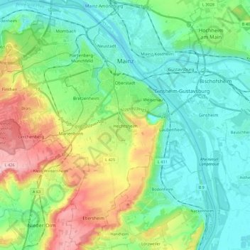
Name: Mainz topographic map, elevation, terrain.
Location: Mainz, Rhineland-Palatinate, Germany (49.89553 8.14309 50.03530 8.34226)
Average elevation: 131 m
Minimum elevation: 78 m
Maximum elevation: 261 m
The destruction caused by the bombing of Mainz during World War II led to the most intense phase of building in the history of the town. During the last war in Germany, more than 30 air raids destroyed about 80 per cent of the city's centre, including most of the historic buildings. The attack on the afternoon of 27 February 1945 remains the most destructive of all 33 bombings that Mainz has suffered in World War II in the collective memory of most of the population living then. The air raid caused most of the dead and made an already hard-hit city largely levelled. Nevertheless, the post-war reconstruction took place very slowly. While cities such as Frankfurt had been rebuilt fast by a central authority, only individual efforts were initially successful in rebuilding Mainz. The reason for this was that the French wanted Mainz to expand and become a model city. Mainz lay within the French-controlled sector of Germany and it was a French architect and town-planner, Marcel Lods, who produced a Le Corbusier-style plan of an ideal architecture. But the very first interest of the inhabitants was the restoration of housing areas. Even after the failure of the model city plans it was the initiative of the French (founding of the Johannes Gutenberg University of Mainz, elevation of Mainz to the state capital of Rhineland-Palatinate, the early resumption of the Mainz carnival) driving the city in a positive development after the war. The City Plan of 1958 by Ernst May allowed a regulated reconstruction for the first time. In 1950, the seat of the government of Rhineland-Palatinate had been transferred to the new Mainz and in 1963 the seat of the new ZDF, notable architects were Adolf Bayer, Richard Jörg and Egon Hartmann. At the time of the two-thousand-years-anniversary in 1962 the city was largely reconstructed. During the 1950s and 1960s, the Oberstadt had been extended, Münchfeld and Lerchenberg added as suburbs, the Altstadttangente (intersection of the old town), new neighbourhoods as Westring and Südring contributed to the extension. By 1970 there remained only a few ruins. The new town hall of Mainz had been designed by Arne Jacobsen and finished by Dissing+Weitling. The town used Jacobsens activity for the Danish Novo company erecting a new office and warehouse building to contact him. The urban renewal of the old town changed the inner city. In the framework of the preparation of the cathedrals millennium, pedestrian zones were developed around the cathedral, in northern direction to the Neubrunnenplatz and in a southern direction across the Leichhof to the Augustinerstraße and Kirschgarten. The 1980s brought the renewal of the façades on the Markt and a new inner-city neighbourhood on the Kästrich. During the 1990s the Kisselberg and the "Fort Malakoff Center" at the site of the old police barracks were built.
Other topographic maps
Click on a map to view its topography, its elevation and its terrain.
Ittel
Germany > Rhineland-Palatinate > Landkreis Trier-Saarburg
Ittel, Welschbillig, Trier-Land, Landkreis Trier-Saarburg, Rhineland-Palatinate, 54664, Germany
Average elevation: 304 m
Ludwigshafen am Rhein
Germany > Rhineland-Palatinate
Ludwigshafen am Rhein, Rhineland-Palatinate, Germany
Average elevation: 96 m
Leubsdorf
Germany > Rhineland-Palatinate > Landkreis Neuwied
Leubsdorf, Linz am Rhein, Landkreis Neuwied, Rhineland-Palatinate, 53547, Germany
Average elevation: 142 m
Bingen am Rhein
Germany > Rhineland-Palatinate > Landkreis Mainz-Bingen
Bingen am Rhein, Landkreis Mainz-Bingen, Rhineland-Palatinate, 55411, Germany
Average elevation: 172 m
Boden
Germany > Rhineland-Palatinate > Westerwaldkreis > Boden
Boden, Montabaur, Westerwaldkreis, Rhineland-Palatinate, Germany
Average elevation: 281 m
Dimbach
Germany > Rhineland-Palatinate > Südwestpfalz > Dimbach
Dimbach, Hauenstein, Südwestpfalz, Rhineland-Palatinate, Germany
Average elevation: 306 m
Sehlem
Germany > Rhineland-Palatinate > Landkreis Bernkastel-Wittlich > Sehlem
Sehlem, Wittlich-Land, Landkreis Bernkastel-Wittlich, Rhineland-Palatinate, Germany
Average elevation: 199 m
Ahrweiler
Germany > Rhineland-Palatinate > Bad Neuenahr-Ahrweiler > Walporzheim
Ahrweiler, Walporzheim, Bad Neuenahr-Ahrweiler, Landkreis Ahrweiler, Rhineland-Palatinate, 53474, Germany
Average elevation: 283 m
Wittlich
Germany > Rhineland-Palatinate > Wittlich
Wittlich, Landkreis Bernkastel-Wittlich, Rhineland-Palatinate, 54516, Germany
Average elevation: 258 m
Rhineland-Palatinate
Germany > Rhineland-Palatinate
Rhineland-Palatinate, Germany
Average elevation: 296 m
Koblenz
Germany > Rhineland-Palatinate > Koblenz
Koblenz, Rhineland-Palatinate, 56068, Germany
Average elevation: 181 m
Katzwinkel (Sieg)
Germany > Rhineland-Palatinate > Katzwinkel (Sieg)
Katzwinkel (Sieg), Wissen, Landkreis Altenkirchen, Rhineland-Palatinate, 57581, Germany
Average elevation: 283 m
Mainz
Germany > Rhineland-Palatinate > Mainz
Mainz, Rhineland-Palatinate, 55116, Germany
Average elevation: 183 m
Montabaur
Germany > Rhineland-Palatinate > Montabaur
Montabaur, Westerwaldkreis, Rhineland-Palatinate, 56410, Germany
Average elevation: 302 m
Matthias
Germany > Rhineland-Palatinate > Trier
Matthias, Süd, Trier, Rhineland-Palatinate, Germany
Average elevation: 161 m
Kaan
Germany > Rhineland-Palatinate > Kaan
Kaan, Maifeld, Landkreis Mayen-Koblenz, Rhineland-Palatinate, 56751, Germany
Average elevation: 207 m