
Babītes novads topographic map
Interactive map
Click on the map to display elevation.
About this map
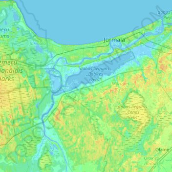
Name: Babītes novads topographic map, elevation, terrain.
Location: Babītes novads, Vidzeme, Letland (56.80090 23.49441 56.98913 24.01246)
Average elevation: 6 m
Minimum elevation: -7 m
Maximum elevation: 23 m
Other topographic maps
Click on a map to view its topography, its elevation and its terrain.
Carnikavas novads
Carnikavas novads, Vidzeme, LV-2163, Letland
Average elevation: 5 m
Brantu dzirnavezers
Letland > Vidzeme > Raunas pagasts
Brantu dzirnavezers, Smiltenes iela, Bormaņi 1, Raunas pagasts, Raunas novads, Vidzeme, LV-4131, Letland
Average elevation: 191 m
Gauja / Koiva jõgi
Gauja / Koiva jõgi, Raunas novads, Vidzeme, LV-4125, Letland
Average elevation: 102 m