
Brooklyn topographic map
Interactive map
Click on the map to display elevation.
About this map
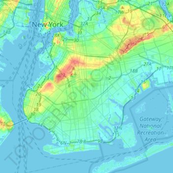
Name: Brooklyn topographic map, elevation, terrain.
Location: Brooklyn, Kings County, New York, United States (40.57002 -74.04197 40.73940 -73.85563)
Average elevation: 10 m
Minimum elevation: -10 m
Maximum elevation: 61 m
Other topographic maps
Click on a map to view its topography, its elevation and its terrain.
Staten Island
United States > New York > New York
Staten Island, New York, United States
Average elevation: 11 m
New York County
United States > New York > New York
New York County, New York, United States
Average elevation: 16 m