
Barents Island topographic map
Interactive map
Click on the map to display elevation.
About this map
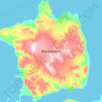
Name: Barents Island topographic map, elevation, terrain.
Location: Barents Island, Svalbard, Norway (78.20174 20.14429 78.63831 22.20408)
Average elevation: 131 m
Minimum elevation: -3 m
Maximum elevation: 655 m
Other topographic maps
Click on a map to view its topography, its elevation and its terrain.
Sande
Sande, Holmestrand, Vestfold og Telemark, 3070, Norway
Average elevation: 37 m
Porsgrunn
Porsgrunn, Vestfold og Telemark, Norway
Average elevation: 87 m
Olonkin City
Norway > Jan Mayen > Olonkin City
Olonkin City, Jan Mayen, Norway
Average elevation: 153 m