
Mount Cook topographic map
Interactive map
Click on the map to display elevation.
About this map
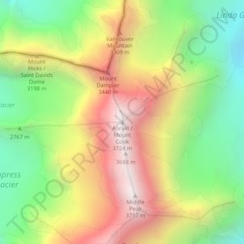
Name: Mount Cook topographic map, elevation, terrain.
Location: Mount Cook, Mackenzie District, Canterbury, New Zealand (-43.59505 170.14212 -43.59495 170.14222)
Average elevation: 2,920 m
Minimum elevation: 2,235 m
Maximum elevation: 3,709 m
Other topographic maps
Click on a map to view its topography, its elevation and its terrain.
Twizel
New Zealand > Canterbury > Mackenzie District > Twizel
Twizel, Mackenzie District, Canterbury, 7901, New Zealand
Average elevation: 472 m