
Bhatsa topographic map
Interactive map
Click on the map to display elevation.
About this map
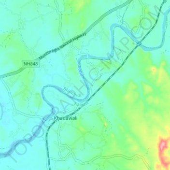
Name: Bhatsa topographic map, elevation, terrain.
Location: Bhatsa, Kalyan-Dombivli, Thane, Maharashtra, 421301, India (19.34219 73.19312 19.39496 73.25886)
Average elevation: 32 m
Minimum elevation: 7 m
Maximum elevation: 133 m
Other topographic maps
Click on a map to view its topography, its elevation and its terrain.
Ulhas River
India > Maharashtra > Kalyan-Dombivli
Ulhas River, Kalyan-Dombivli, Thane, Maharashtra, 421301, India
Average elevation: 17 m
Tansa River
India > Maharashtra > Kalyan-Dombivli
Tansa River, Kalyan-Dombivli, Thane, Maharashtra, 421301, India
Average elevation: 84 m