
Gunpo-si topographic map
Interactive map
Click on the map to display elevation.
About this map
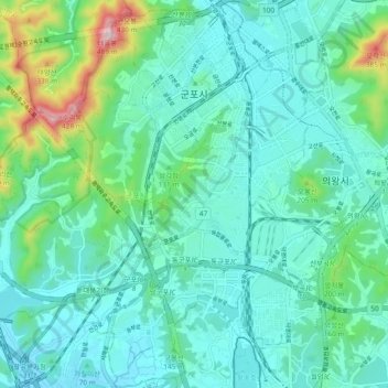
Name: Gunpo-si topographic map, elevation, terrain.
Location: Gunpo-si, Gyeonggi-do, South Korea (37.30478 126.87323 37.37931 126.96244)
Average elevation: 102 m
Minimum elevation: 18 m
Maximum elevation: 462 m
Other topographic maps
Click on a map to view its topography, its elevation and its terrain.
Bora-dong
South Korea > Gyeonggi-do > Yongin-si > Giheung-gu > Bora-dong
Bora-dong, Giheung-gu, Yongin-si, Gyeonggi-do, 17080, South Korea
Average elevation: 92 m