
Cameroon topographic map
Interactive map
Click on the map to display elevation.
About this map
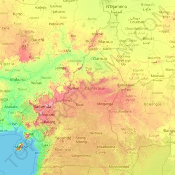
Name: Cameroon topographic map, elevation, terrain.
Location: Cameroon (1.65179 8.38222 13.08333 16.19110)
Average elevation: 473 m
Minimum elevation: -1 m
Maximum elevation: 3,328 m
Cameroon is divided into five major geographic zones distinguished by dominant physical, climatic, and vegetative features. The coastal plain extends 15 to 150 kilometres (9 to 93 mi) inland from the Gulf of Guinea and has an average elevation of 90 metres (295 ft). Exceedingly hot and humid with a short dry season, this belt is densely forested and includes some of the wettest places on earth, part of the Cross-Sanaga-Bioko coastal forests.
Other topographic maps
Click on a map to view its topography, its elevation and its terrain.
Sri Lanka
Sri Lanka
Average elevation: 50 m
India
India
Average elevation: 1,017 m
Hyderabad
India > Telangana > Bahadurpura mandal
Hyderabad, Bahadurpura mandal, Hyderabad District, Telangana, India
Average elevation: 549 m
Montreal
Canada > Quebec > Urban agglomeration of Montreal > Montreal
Montreal, Urban agglomeration of Montreal, Montreal (06), Quebec, H3B 1M7, Canada
Average elevation: 30 m
Kanyakumari district
Kanyakumari district, Tamil Nadu, India
Average elevation: 226 m
Snohomish County
Snohomish County, Washington, United States
Average elevation: 649 m
Pune
India > Maharashtra > Pune City > Pune
Pune, Pune City, Pune District, Maharashtra, 411001, India
Average elevation: 641 m
Anaikatti
India > Tamil Nadu > Coimbatore North
Anaikatti, Mannarkad, Palakkad District, Kerala, 678741, India
Average elevation: 623 m
Bhatwari
Bhatwari, Uttarkashi District, Uttarakhand, India
Average elevation: 4,570 m
Musi River
Musi River, Hyderabad, Uppal mandal, Medchal–Malkajgiri, Telangana, 5000036, India
Average elevation: 490 m
Dehradun
India > Uttarakhand > Dehradun
Dehradun, Dehradun District, Uttarakhand, 248001, India
Average elevation: 904 m
Bengaluru
India > Karnataka > Bangalore North
Bengaluru, Bangalore North, Bengaluru Urban, Karnataka, India
Average elevation: 886 m
Nepal
Nepal
Average elevation: 2,604 m
Mandi
India > Himachal Pradesh > Mandi
Mandi, Mandi District, Himachal Pradesh, 175001, India
Average elevation: 1,273 m
Ocheretyne
Ocheretyne, Ocheretyne settlement hromada, Pokrovskii Raion, Donetsk Oblast, 86020, Ukraine
Average elevation: 227 m
Blairingone
United Kingdom > Scotland > Perth and Kinross
Blairingone, Perth and Kinross, Scotland, FK14 7NU, United Kingdom
Average elevation: 93 m
Sector 62
India > Haryana > Gurugram District
Sector 62, Gurgaon, Gurugram District, Haryana, India
Average elevation: 235 m
Vitoria-Gasteiz
Spain > Autonomous Community of the Basque Country > Gasteizko kuadrilla/Cuadrilla de Vitoria
Vitoria-Gasteiz, Gasteizko kuadrilla/Cuadrilla de Vitoria, Álava, Autonomous Community of the Basque Country, Spain
Average elevation: 626 m
San Pedro de Quemes
Bolivia > Potosí > Provincia Nor Lípez > Municipio San Pedro de Quemes
San Pedro de Quemes, Canton San Pedro de Quemes, Municipio San Pedro de Quemes, Provincia Nor Lípez, Potosí, Bolivia
Average elevation: 3,710 m
Ammanapura Doddi
India > Karnataka > Ramanagara taluk
Ammanapura Doddi, Ramanagara taluk, Ramanagara District, Karnataka, 562138, India
Average elevation: 717 m
Tacoma
United States > Washington > Pierce County
Tacoma, Pierce County, Washington, United States
Average elevation: 67 m
Marin County
Marin County, California, United States
Average elevation: 69 m
Tancolaiuan Island
Philippines > Tawi-Tawi > South Ubian
Tancolaiuan Island, South Ubian, Tawi-Tawi, Bangsamoro, 7504, Philippines
Average elevation: 2 m
Bowling Green
United States > Kentucky > Warren County
Bowling Green, Warren County, Kentucky, 42101, United States
Average elevation: 169 m
Broomehill Village
Broomehill Village, Shire Of Broomehill-Tambellup, Western Australia, Australia
Average elevation: 325 m
Chennai
India > Tamil Nadu > Chennai
Chennai, Chennai District, Tamil Nadu, India
Average elevation: 8 m
Mangaluru
India > Karnataka > Mangaluru taluk
Mangaluru, Mangaluru taluk, Dakshina Kannada District, Karnataka, 575001, India
Average elevation: 25 m
Navi Mumbai
India > Maharashtra > Thane > Navi Mumbai
Navi Mumbai, Mumbai Metropolitan Region, Thane, Maharashtra, 400706, India
Average elevation: 30 m
Vadodara
India > Gujarat > Vadodara Taluka
Vadodara, Vadodara Taluka, Vadodara District, Gujarat, 390001, India
Average elevation: 36 m
Surat
India > Gujarat > Katargam Taluka > Surat
Surat, Katargam Taluka, Surat, Gujarat, 395001, India
Average elevation: 11 m
Bhopal
India > Madhya Pradesh > Huzur Tahsil
Bhopal, Huzur Tahsil, Bhopal District, Madhya Pradesh, 462001, India
Average elevation: 498 m