
Kaiga topographic map
Interactive map
Click on the map to display elevation.
About this map
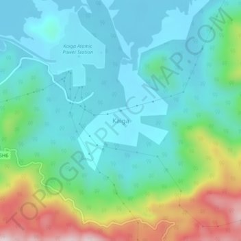
Name: Kaiga topographic map, elevation, terrain.
Location: Kaiga, Karwar taluk, Uttara Kannada District, Karnataka, India (14.83417 74.42585 14.87417 74.46585)
Average elevation: 155 m
Minimum elevation: 29 m
Maximum elevation: 531 m
Other topographic maps
Click on a map to view its topography, its elevation and its terrain.
Kadra
India > Karnataka > Karwar taluk
Kadra, Karwar taluk, Uttara Kannada District, Karnataka, India
Average elevation: 33 m
Karwar
India > Karnataka > Karwar taluk
Karwar, Karwar taluk, Uttara Kannada, Karnataka, 581300, India
Average elevation: 42 m