
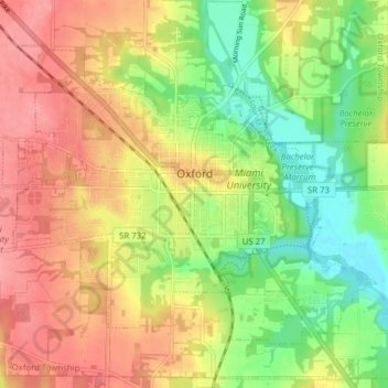
Oxford topographic map
Interactive map
Click on the map to display elevation.
About this map
Name: Oxford topographic map, elevation, terrain.
Average elevation: 279 m
Minimum elevation: 233 m
Maximum elevation: 321 m
Other topographic maps
Click on a map to view its topography, its elevation and its terrain.
Oxford Township
United States > Ohio > Butler County
Oxford Township, Butler County, Ohio, 45056, United States
Average elevation: 289 m
Darrtown
United States > Ohio > Butler County
Darrtown, Milford Township, Butler County, Ohio, United States
Average elevation: 238 m
Okeana
United States > Ohio > Butler County
Okeana, Morgan Township, Butler County, Ohio, 45053, United States
Average elevation: 226 m
Wieche Field
United States > Ohio > Butler County > Seven Mile
Wieche Field, Seven Mile, Wayne Township, Butler County, Ohio, United States
Average elevation: 208 m
Woodsdale
United States > Ohio > Butler County
Woodsdale, Madison Township, Butler County, Ohio, 45055, United States
Average elevation: 204 m
Wetherington
United States > Ohio > Butler County > Wetherington
Wetherington, West Chester Township, Butler County, Ohio, United States
Average elevation: 261 m
Jacksonburg
United States > Ohio > Butler County
Jacksonburg, Wayne Township, Butler County, Ohio, United States
Average elevation: 285 m
Williamsdale
United States > Ohio > Butler County
Williamsdale, St. Clair Township, Butler County, Ohio, 45055, United States
Average elevation: 193 m
Somerville
United States > Ohio > Butler County
Somerville, Milford Township, Butler County, Ohio, United States
Average elevation: 256 m
Seven Mile
United States > Ohio > Butler County
Seven Mile, Wayne Township, Butler County, Ohio, 45062, United States
Average elevation: 209 m
Millville
United States > Ohio > Butler County
Millville, Ross Township, Butler County, Ohio, United States
Average elevation: 207 m
College Corner
United States > Ohio > Butler County
College Corner, Oxford Township, Butler County, Ohio, United States
Average elevation: 304 m
Lemon Township
United States > Ohio > Butler County
Lemon Township, Butler County, Ohio, United States
Average elevation: 213 m
Madison Township
United States > Ohio > Butler County
Madison Township, Butler County, Ohio, United States
Average elevation: 229 m
Trenton
United States > Ohio > Butler County
Trenton, Butler County, Ohio, 45067, United States
Average elevation: 200 m
West Chester
United States > Ohio > Butler County > West Chester
West Chester, West Chester Township, Butler County, Ohio, 45069, United States
Average elevation: 231 m
Morgan Township
United States > Ohio > Butler County
Morgan Township, Butler County, Ohio, United States
Average elevation: 237 m
Liberty Township
United States > Ohio > Butler County
Liberty Township, Butler County, Ohio, United States
Average elevation: 233 m
Bethany
United States > Ohio > Butler County
Bethany, Liberty Township, Butler County, Ohio, United States
Average elevation: 259 m
Peffer Park
United States > Ohio > Butler County > Oxford
Peffer Park, Oxford, Oxford Township, Butler County, Ohio, United States
Average elevation: 265 m
Macedonia
United States > Ohio > Butler County
Macedonia, Morgan Township, Butler County, Ohio, 45053, United States
Average elevation: 247 m
Ross Township
United States > Ohio > Butler County
Ross Township, Butler County, Ohio, 45061, United States
Average elevation: 211 m
Hanover Township
United States > Ohio > Butler County
Hanover Township, Butler County, Ohio, United States
Average elevation: 245 m
Fairfield Township
United States > Ohio > Butler County
Fairfield Township, Butler County, Ohio, 45011, United States
Average elevation: 207 m
Beckett Ridge
United States > Ohio > Butler County > Beckett Ridge
Beckett Ridge, West Chester Township, Butler County, Ohio, United States
Average elevation: 211 m
Wayne Township
United States > Ohio > Butler County
Wayne Township, Butler County, Ohio, 45062, United States
Average elevation: 261 m
Astoria
United States > Ohio > Butler County
Astoria, Madison Township, Butler County, Ohio, United States
Average elevation: 263 m
West Chester Township
United States > Ohio > Butler County
West Chester Township, Butler County, Ohio, 45069, United States
Average elevation: 230 m
Hamilton
United States > Ohio > Butler County
Hamilton, Butler County, Ohio, 45013, United States
Average elevation: 210 m
Ross
United States > Ohio > Butler County
Ross, Ross Township, Butler County, Ohio, 45061, United States
Average elevation: 185 m
Olde West Chester
United States > Ohio > Butler County
Olde West Chester, West Chester Township, Butler County, Ohio, United States
Average elevation: 227 m
Crawford Woods
United States > Ohio > Butler County > Hamilton
Crawford Woods, East Hamilton, Hamilton, Butler County, Ohio, United States
Average elevation: 205 m
Middletown
United States > Ohio > Butler County
Middletown, Butler County, Ohio, United States
Average elevation: 216 m
Reily
United States > Ohio > Butler County > Reily
Reily, Reily Township, Butler County, Ohio, United States
Average elevation: 255 m
Fairfield
United States > Ohio > Butler County
Fairfield, Butler County, Ohio, United States
Average elevation: 213 m
Oneida
United States > Ohio > Butler County > Middletown
Oneida, Middletown, Butler County, Ohio, 45044, United States
Average elevation: 204 m
New Miami
United States > Ohio > Butler County
New Miami, St. Clair Township, Butler County, Ohio, United States
Average elevation: 188 m
Gano
United States > Ohio > Butler County
Gano, West Chester Township, Butler County, Ohio, 45241, United States
Average elevation: 211 m
Monroe
United States > Ohio > Butler County
Monroe, Lemon Township, Butler County, Ohio, United States
Average elevation: 221 m