
Fountain County topographic map
Interactive map
Click on the map to display elevation.
About this map
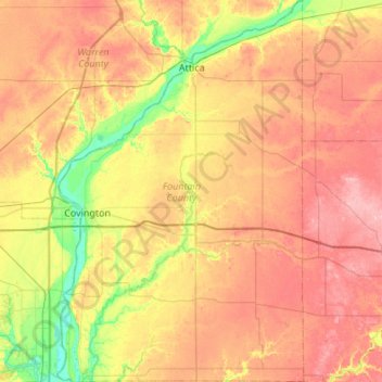
Name: Fountain County topographic map, elevation, terrain.
Location: Fountain County, Indiana, United States (39.95245 -87.44019 40.36639 -87.09014)
Average elevation: 206 m
Minimum elevation: 144 m
Maximum elevation: 264 m
According to the 2010 United States Census, the county has a total area of 397.88 square miles (1,030.5 km2), of which 395.66 square miles (1,024.8 km2) (or 99.44%) is land and 2.22 square miles (5.7 km2) (or 0.56%) is water. Elevations range from 770 feet (230 m) above sea level in the northeastern part of the county to 465 feet (142 m) in the southwest where the Wabash River leaves the county. The county is within the drainage basin of the Wabash River, sloping to the southwest. It is covered with loess ranging in thickness from a few inches to more than 7 feet (2.1 m). Approximately 84 percent of the county's land is use for agriculture.
Other topographic maps
Click on a map to view its topography, its elevation and its terrain.
Carmel
United States > Indiana > Hamilton County
Carmel, Hamilton County, Indiana, United States
Average elevation: 253 m
Indianapolis
United States > Indiana > Indianapolis
Indianapolis, Marion County, Indiana, 46204, United States
Average elevation: 241 m
Terre Haute
United States > Indiana > Vigo County
Terre Haute, Vigo County, Indiana, United States
Average elevation: 159 m
Angola
United States > Indiana > Steuben County
Angola, Steuben County, Indiana, United States
Average elevation: 315 m
Arlington
United States > Indiana > Rush County
Arlington, Rush County, Indiana, 46104, United States
Average elevation: 280 m
Cicero
United States > Indiana > Hamilton County
Cicero, Hamilton County, Indiana, 46034, United States
Average elevation: 252 m
Larwill
United States > Indiana > Whitley County
Larwill, Whitley County, Indiana, United States
Average elevation: 288 m
Winfield Township
United States > Indiana > Lake County
Winfield Township, Lake County, Indiana, United States
Average elevation: 220 m
Hartleyville
United States > Indiana > Lawrence County
Hartleyville, Lawrence County, Indiana, United States
Average elevation: 185 m
Sellersburg
United States > Indiana > Clark County
Sellersburg, Clark County, Indiana, 47172, United States
Average elevation: 149 m
Union City
United States > Indiana > Randolph County
Union City, Randolph County, Indiana, United States
Average elevation: 333 m
La Paz
United States > Indiana > Marshall County
La Paz, Marshall County, Indiana, 46537, United States
Average elevation: 261 m
Vanderburgh County
Vanderburgh County, Indiana, United States
Average elevation: 127 m
Selma
United States > Indiana > Delaware County
Selma, Delaware County, Indiana, United States
Average elevation: 304 m
Bright
United States > Indiana > Dearborn County
Bright, Miller Township, Dearborn County, Indiana, United States
Average elevation: 222 m
Muncie
United States > Indiana > Delaware County
Muncie, Delaware County, Indiana, United States
Average elevation: 291 m
Beamer
United States > Indiana > Owen County
Beamer, Owen County, Indiana, United States
Average elevation: 206 m
Bristow
United States > Indiana > Perry County
Bristow, Perry County, Indiana, United States
Average elevation: 157 m
Upland
United States > Indiana > Grant County
Upland, Grant County, Indiana, United States
Average elevation: 278 m
Lawrence County
Lawrence County, Indiana, United States
Average elevation: 203 m
Ohio County
Ohio County, Indiana, 47040, United States
Average elevation: 223 m
Parkers Settlement
United States > Indiana > Posey County
Parkers Settlement, Posey County, Indiana, United States
Average elevation: 141 m
Lake James
United States > Indiana > Steuben County
Lake James, Steuben County, Indiana, 46703, United States
Average elevation: 303 m
Vincennes
United States > Indiana > Knox County
Vincennes, Knox County, Indiana, 47591, United States
Average elevation: 134 m
Saint Joseph County
Saint Joseph County, Indiana, United States
Average elevation: 239 m
Twin Lakes
United States > Indiana > LaGrange County
Twin Lakes, LaGrange County, Indiana, United States
Average elevation: 262 m
Evansville
United States > Indiana > Vanderburgh County
Evansville, Vanderburgh County, Indiana, United States
Average elevation: 122 m
West Lafayette
United States > Indiana > Tippecanoe County
West Lafayette, Tippecanoe County, Indiana, United States
Average elevation: 192 m
Henryville
United States > Indiana > Clark County
Henryville, Clark County, Indiana, 47126, United States
Average elevation: 166 m
Amboy
United States > Indiana > Miami County
Amboy, Miami County, Indiana, United States
Average elevation: 251 m
Walkerton
United States > Indiana > Saint Joseph County
Walkerton, Saint Joseph County, Indiana, 46574, United States
Average elevation: 218 m
Lake Seven
United States > Indiana > Lake County > Crown Point
Lake Seven, Crown Point, Lake County, Indiana, United States
Average elevation: 220 m
Johnson County
United States > Indiana > Johnson County
Johnson County, Indiana, United States
Average elevation: 232 m
Bartholomew County
Bartholomew County, Indiana, United States
Average elevation: 209 m
Goshen
United States > Indiana > Scott County
Goshen, Scott County, Indiana, United States
Average elevation: 181 m
Lake Windemere
United States > Indiana > Hamilton County > Carmel
Lake Windemere, Carmel, Hamilton County, Indiana, United States
Average elevation: 273 m
Linton
United States > Indiana > Greene County
Linton, Greene County, Indiana, 47441, United States
Average elevation: 161 m
Vevay
United States > Indiana > Switzerland County
Vevay, Switzerland County, Indiana, United States
Average elevation: 164 m
Country Club Meadows
United States > Indiana > Vanderburgh County > Evansville
Country Club Meadows, Evansville, Vanderburgh County, Indiana, 47710, United States
Average elevation: 126 m