
Mexico topographic map
Interactive map
Click on the map to display elevation.
About this map
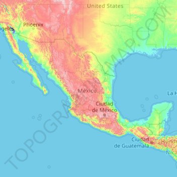
Name: Mexico topographic map, elevation, terrain.
Location: Mexico (14.38862 -118.59919 32.71866 -86.49327)
Average elevation: 412 m
Minimum elevation: -71 m
Maximum elevation: 4,223 m
Mexico is crossed from north to south by two mountain ranges known as Sierra Madre Oriental and Sierra Madre Occidental, which are the extension of the Rocky Mountains from northern North America. From east to west at the center, the country is crossed by the Trans-Mexican Volcanic Belt also known as the Sierra Nevada. A fourth mountain range, the Sierra Madre del Sur, runs from Michoacán to Oaxaca. As such, the majority of the Mexican central and northern territories are located at high altitudes, and the highest elevations are found at the Trans-Mexican Volcanic Belt: Pico de Orizaba (5,700 m or 18,701 ft), Popocatépetl (5,462 m or 17,920 ft) and Iztaccihuatl (5,286 m or 17,343 ft) and the Nevado de Toluca (4,577 m or 15,016 ft). Three major urban agglomerations are located in the valleys between these four elevations: Toluca, Greater Mexico City and Puebla. An important geologic feature of the Yucatán peninsula is the Chicxulub crater. The scientific consensus is that the Chicxulub impactor was responsible for the Cretaceous–Paleogene extinction event. Mexico is subject to a number of natural hazards, including hurricanes on both coasts, tsunamis on the Pacific coast, and volcanism.
Other topographic maps
Click on a map to view its topography, its elevation and its terrain.
India
India
Average elevation: 1,017 m
Hyderabad
India > Telangana > Bahadurpura mandal
Hyderabad, Bahadurpura mandal, Hyderabad District, Telangana, India
Average elevation: 549 m
Montreal
Canada > Quebec > Urban agglomeration of Montreal > Montreal
Montreal, Urban agglomeration of Montreal, Montreal (06), Quebec, H3B 1M7, Canada
Average elevation: 30 m
Sri Lanka
Sri Lanka
Average elevation: 50 m
Pune
India > Maharashtra > Pune City > Pune
Pune, Pune City, Pune District, Maharashtra, 411001, India
Average elevation: 641 m
Snohomish County
Snohomish County, Washington, United States
Average elevation: 649 m
Bhatwari
Bhatwari, Uttarkashi District, Uttarakhand, India
Average elevation: 4,570 m
Surat
India > Gujarat > Katargam Taluka > Surat
Surat, Katargam Taluka, Surat, Gujarat, 395001, India
Average elevation: 11 m
Musi River
Musi River, Hyderabad, Uppal mandal, Medchal–Malkajgiri, Telangana, 5000036, India
Average elevation: 490 m
Chennai
India > Tamil Nadu > Chennai
Chennai, Chennai District, Tamil Nadu, India
Average elevation: 8 m
Bengaluru
India > Karnataka > Bangalore North
Bengaluru, Bangalore North, Bengaluru Urban, Karnataka, India
Average elevation: 886 m
Vadodara
India > Gujarat > Vadodara Taluka
Vadodara, Vadodara Taluka, Vadodara District, Gujarat, 390001, India
Average elevation: 36 m
Nepal
Nepal
Average elevation: 2,604 m
Vitoria-Gasteiz
Spain > Autonomous Community of the Basque Country > Gasteizko kuadrilla/Cuadrilla de Vitoria
Vitoria-Gasteiz, Gasteizko kuadrilla/Cuadrilla de Vitoria, Álava, Autonomous Community of the Basque Country, Spain
Average elevation: 626 m
San Pedro de Quemes
Bolivia > Potosí > Provincia Nor Lípez > Municipio San Pedro de Quemes
San Pedro de Quemes, Canton San Pedro de Quemes, Municipio San Pedro de Quemes, Provincia Nor Lípez, Potosí, Bolivia
Average elevation: 3,710 m
Tancolaiuan Island
Philippines > Tawi-Tawi > South Ubian
Tancolaiuan Island, South Ubian, Tawi-Tawi, Bangsamoro, 7504, Philippines
Average elevation: 2 m
Dehradun
India > Uttarakhand > Dehradun
Dehradun, Dehradun District, Uttarakhand, 248001, India
Average elevation: 904 m
Tacoma
United States > Washington > Pierce County
Tacoma, Pierce County, Washington, United States
Average elevation: 67 m
Mangaluru
India > Karnataka > Mangaluru taluk
Mangaluru, Mangaluru taluk, Dakshina Kannada District, Karnataka, 575001, India
Average elevation: 25 m
Rishikesh
India > Uttarakhand > Rishikesh
Rishikesh, Dehradun, Uttarakhand, 249201, India
Average elevation: 497 m
Ammanapura Doddi
India > Karnataka > Ramanagara taluk
Ammanapura Doddi, Ramanagara taluk, Ramanagara District, Karnataka, 562138, India
Average elevation: 717 m
Marin County
Marin County, California, United States
Average elevation: 69 m
Bowling Green
United States > Kentucky > Warren County
Bowling Green, Warren County, Kentucky, 42101, United States
Average elevation: 169 m
Broomehill Village
Broomehill Village, Shire Of Broomehill-Tambellup, Western Australia, Australia
Average elevation: 325 m
Karakulam
India > Kerala > Nedumangad
Karakulam, Nedumangad, Thiruvananthapuram District, Kerala, 695564, India
Average elevation: 57 m
Mattupetty
Mattupetty, Devikulam, Idukki District, Kerala, 685616, India
Average elevation: 1,694 m
Kurunegala
Sri Lanka > North Western Province
Kurunegala, Kurunegala District, North Western Province, 60000, Sri Lanka
Average elevation: 146 m
Bonaventure (MRC)
Bonaventure (MRC), Gaspésie–Îles-de-la-Madeleine, Quebec, Canada
Average elevation: 230 m