
Stewart Island topographic map
Interactive map
Click on the map to display elevation.
About this map
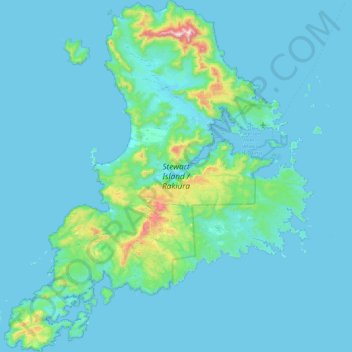
Name: Stewart Island topographic map, elevation, terrain.
Location: Stewart Island, Southland, New Zealand (-47.29000 167.44721 -46.68343 168.22927)
Average elevation: 63 m
Minimum elevation: -2 m
Maximum elevation: 967 m
Although the clay soil is not very fertile, the high rainfall and warm weather mean that the island is densely forested throughout. Native plants include the world's southernmost dense forest of podocarps (southern conifers) and hardwoods such as rātā and kāmahi in the lowland areas with mānuka shrubland at higher elevations. The trees are thought to have become established here since the last ice age from seeds brought across the strait by seabirds, which would explain why the beech trees that are so common in New Zealand, but whose seeds are dispersed by the wind rather than birds, are not found on Stewart Island.
Other topographic maps
Click on a map to view its topography, its elevation and its terrain.
Pukekohe
New Zealand > Auckland > Franklin
Pukekohe, Franklin, Auckland, 2120, New Zealand
Average elevation: 78 m
Doubtful Sound
New Zealand > Southland > Southland District > Fiordland Community
Doubtful Sound, Fiordland Community, Southland District, Southland, New Zealand
Average elevation: 560 m
Pukehina Beach
New Zealand > Bay of Plenty > Western Bay of Plenty District
Pukehina Beach, Western Bay of Plenty District, Bay of Plenty, New Zealand
Average elevation: 3 m
Pyramid Valley
New Zealand > Canterbury > Hurunui District
Pyramid Valley, Hurunui District, Canterbury, 7491, New Zealand
Average elevation: 366 m
Fiordland Community
New Zealand > Southland > Southland District
Fiordland Community, Southland District, Southland, New Zealand, Depth Peak
Average elevation: 680 m
Raetihi
New Zealand > Manawatu-Whanganui > Ruapehu District
Raetihi, Ruapehu District, Manawatū-Whanganui, 4625, New Zealand
Average elevation: 743 m
Linwood-Central-Heathcote Community
New Zealand > Canterbury > Christchurch City
Linwood-Central-Heathcote Community, Christchurch City, Canterbury, New Zealand
Average elevation: 55 m
Te Awanga
New Zealand > Hawke's Bay > Hastings District
Te Awanga, Hastings District, Hawke's Bay, 4180, New Zealand
Average elevation: 22 m
Adams Peak
New Zealand > Manawatu-Whanganui > Palmerston North
Adams Peak, Palmerston North, Manawatū-Whanganui, 4810, New Zealand
Average elevation: 197 m
Maungakiekie-Tāmaki
Maungakiekie-Tāmaki, Auckland, New Zealand
Average elevation: 23 m
Knuckles
New Zealand > Canterbury > Selwyn District
Knuckles, Selwyn District, Canterbury, New Zealand
Average elevation: 980 m
Whangarei
New Zealand > Northland > Whangarei District
Whangarei, Whangarei District, Northland, 0110, New Zealand
Average elevation: 96 m
Mahia Peninsula
New Zealand > Hawke's Bay > Wairoa District
Mahia Peninsula, Wairoa District, Hawke's Bay, 4198, New Zealand
Average elevation: 41 m
Hibiscus Coast
Hibiscus Coast, Hibiscus and Bays, Auckland, 0932, New Zealand
Average elevation: 40 m
Flagpole
New Zealand > Canterbury > Selwyn District
Flagpole, Selwyn District, Canterbury, New Zealand
Average elevation: 570 m
Halswell-Hornby-Riccarton Community
New Zealand > Canterbury > Christchurch City
Halswell-Hornby-Riccarton Community, Christchurch City, Canterbury, New Zealand
Average elevation: 49 m
352
New Zealand > Southland > Southland District > Fiordland Community
352, Fiordland Community, Southland District, Southland, New Zealand
Average elevation: 273 m
Kaipara District
New Zealand > Northland > Kaipara District
Kaipara District, Northland, New Zealand
Average elevation: 68 m
Wānaka
New Zealand > Otago > Queenstown-Lakes District
Wānaka, Queenstown-Lakes District, Otago, 9305, New Zealand
Average elevation: 381 m
Twizel
New Zealand > Canterbury > Mackenzie District > Twizel
Twizel, Mackenzie District, Canterbury, 7901, New Zealand
Average elevation: 472 m
Waitangi
New Zealand > Northland > Far North District > Bay of Islands-Whangaroa Community > Waitangi
Waitangi, Bay of Islands-Whangaroa Community, Far North District, Northland, 0247, New Zealand
Average elevation: 15 m
Invercargill
New Zealand > Southland > Invercargill City > Invercargill
Invercargill, Invercargill City, Southland, 9810, New Zealand
Average elevation: 16 m
Oban
New Zealand > Southland > Southland District > Stewart Island/Rakiura Community > Oban
Oban, Stewart Island/Rakiura Community, Southland District, Southland, 9818, New Zealand
Average elevation: 23 m
Te Anau
New Zealand > Southland > Southland District > Fiordland Community > Te Anau
Te Anau, Fiordland Community, Southland District, Southland, 9600, New Zealand
Average elevation: 249 m
Timaru
New Zealand > Canterbury > Timaru District > Timaru
Timaru, Timaru District, Canterbury, 7910, New Zealand
Average elevation: 16 m
Dunedin
New Zealand > Otago > Dunedin City > Dunedin
Dunedin, Dunedin City, Otago, 9016, New Zealand
Average elevation: 110 m
Blenheim
New Zealand > Marlborough > Blenheim
Blenheim, Marlborough, 7301, New Zealand
Average elevation: 20 m
Runciman
New Zealand > Auckland > Franklin > Runciman
Runciman, Franklin, Auckland, 2578, New Zealand
Average elevation: 20 m
Invercargill City
Invercargill City, Southland, New Zealand
Average elevation: 11 m
Upper Hutt
New Zealand > Wellington > Upper Hutt City > Upper Hutt
Upper Hutt, Upper Hutt City, Wellington, 5218, New Zealand
Average elevation: 271 m
Kokatahi River
New Zealand > Westland District
Kokatahi River, Westland District, West Coast, New Zealand
Average elevation: 516 m
Māngere-Ōtāhuhu
New Zealand > Auckland > Māngere-Ōtāhuhu
Māngere-Ōtāhuhu, Auckland, New Zealand
Average elevation: 10 m
Queenstown
New Zealand > Otago > Queenstown-Lakes District > Queenstown
Queenstown, Queenstown-Lakes District, Otago, 9348, New Zealand
Average elevation: 592 m
Porirua
New Zealand > Wellington > Porirua
Porirua, Porirua City, Wellington, 5022, New Zealand
Average elevation: 115 m
Christchurch
New Zealand > Canterbury > Christchurch City > Christchurch
Christchurch, Christchurch City, Canterbury, New Zealand
Average elevation: 41 m
South Wairarapa District
South Wairarapa District, Wellington, New Zealand
Average elevation: 189 m
Mount Ruapehu
Mount Ruapehu, Ruapehu District, Manawatu-Wanganui, New Zealand
Average elevation: 2,439 m
Amherst Glacier
Amherst Glacier, Scone Creek Track, Westland District, West Coast, New Zealand
Average elevation: 1,819 m
Pickelhaube Glacier
Pickelhaube Glacier, Westland District, West Coast, New Zealand
Average elevation: 1,836 m