
Rohini topographic map
Interactive map
Click on the map to display elevation.
About this map
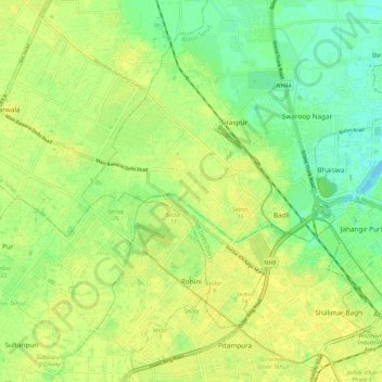
Name: Rohini topographic map, elevation, terrain.
Location: Rohini, Rohini Tehsil, North West Delhi District, Delhi, India (28.69501 77.03126 28.78480 77.14552)
Average elevation: 215 m
Minimum elevation: 204 m
Maximum elevation: 221 m
Other topographic maps
Click on a map to view its topography, its elevation and its terrain.
Sector 40
India > Delhi > Rohini Tehsil
Sector 40, Rohini, Rohini Tehsil, North West Delhi, Delhi, India
Average elevation: 215 m
Sector 11
India > Delhi > Rohini Tehsil
Sector 11, Rohini, Rohini Tehsil, North West Delhi, Delhi, India
Average elevation: 216 m