
Nord-Pas-de-Calais topographic map
Interactive map
Click on the map to display elevation.
About this map
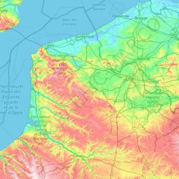
Name: Nord-Pas-de-Calais topographic map, elevation, terrain.
Location: Nord-Pas-de-Calais, Metropolitan France, France (49.96892 1.55562 51.08899 4.23119)
Average elevation: 55 m
Minimum elevation: -4 m
Maximum elevation: 246 m
Other topographic maps
Click on a map to view its topography, its elevation and its terrain.
Villeneuve-des-Escaldes
France > Occitania > Pyrénées-Orientales > Angoustrine-Villeneuve-des-Escaldes
Average elevation: 1,372 m
La Jalousie
France > Pays de la Loire > Vendée > Montaigu-Vendée > Saint-Hilaire-de-Loulay
Average elevation: 49 m
city de boutet de monvel (ethanlecartographe
France > Grand Est > Meurthe-et-Moselle > Lunéville
Average elevation: 240 m
Pic du Midi de Bigorre
France > Occitania > Hautes Pyrenees > Bagnères-de-Bigorre
Average elevation: 2,280 m
Toulouse
France > Occitania > Haute-Garonne > Toulouse
The first half of the 14th century was a prosperous period, despite the dismemberment in 1317 of the very large bishopric of Toulouse (which lost two-thirds of its area and part of its income, not compensated by its elevation to the rank of archbishopric), and the episode of the Shepherds' Crusade which…
Average elevation: 173 m
Avignon
France > Provence-Alpes-Côte d'Azur > Vaucluse > Avignon
Enclosed by the city walls, the Rocher des Doms is a limestone elevation of Urgonian type, 35 metres high (and therefore safe from flooding of the Rhone which it overlooks) and is the original core of the city. Several limestone massifs are present around the commune (the Massif des Angles,…
Average elevation: 58 m
Fatu Huku
France > French Polynesia > Hiva Oa
The island is essentially a huge rock, looming steep-sided out of the ocean and rising to a flattened plateau with a maximum elevation of 361 metres (1,184 ft). Fatu Huku is the youngest of the volcanic Marquesas Islands, estimated to be only 1.3 million years old which accounts, in part, for its ruggedness as…
Average elevation: 8 m
Le Pied du Col
France > Provence-Alpes-Côte d'Azur > Hautes-Alpes > Villar-d'Arêne > Le Pied du Col
Average elevation: 2,101 m