
Red Lake County topographic map
Interactive map
Click on the map to display elevation.
About this map
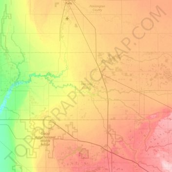
Name: Red Lake County topographic map, elevation, terrain.
Location: Red Lake County, Minnesota, United States (47.75957 -96.48255 47.96464 -95.70915)
Average elevation: 341 m
Minimum elevation: 268 m
Maximum elevation: 419 m
The Red Lake River flows southward into the county from Pennington County. It is joined near Red Lake Falls by the Clearwater River; the combined flow (still known as the Red Lake River) flows southwestward to Huot, where it is augmented by the Black River, which drains the northwestern part of the county. The Red Lake River then flows southwestward into Polk County. The county terrain consists of low rolling hills, etched by drainages and gullies. The area is devoted to agriculture. The county terrain slopes to the west, with its highest elevation on its southeastern corner, at 1,201 ft (366 m) ASL. The county has a total area of 432 square miles (1,120 km2), of which 432 square miles (1,120 km2) is land and 0.09 square miles (0.23 km2) (0.02%) is water.
Other topographic maps
Click on a map to view its topography, its elevation and its terrain.
Stark
United States > Minnesota > Brown County
Stark, Brown County, Minnesota, United States
Average elevation: 307 m
Hubbard County
Hubbard County, Minnesota, United States
Average elevation: 445 m
Northfield
United States > Minnesota > Rice County
Northfield, Rice County, Minnesota, 55057, United States
Average elevation: 300 m
Marshall County
Marshall County, Minnesota, United States
Average elevation: 307 m
Norman County
Norman County, Minnesota, United States
Average elevation: 303 m
Mahnomen County
Mahnomen County, Minnesota, United States
Average elevation: 411 m
Pennington County
Pennington County, Minnesota, United States
Average elevation: 338 m
Long Lake
United States > Minnesota > Hennepin County
Long Lake, Hennepin County, Minnesota, 55356, United States
Average elevation: 300 m
West Cook
United States > Minnesota > Cook County
West Cook, Cook County, Minnesota, 55604, United States
Average elevation: 501 m
Sandstone
United States > Minnesota > Pine County
Sandstone, Pine County, Minnesota, United States
Average elevation: 332 m
Montgomery
United States > Minnesota > Le Sueur County
Montgomery, Le Sueur County, Minnesota, 56069, United States
Average elevation: 323 m
Mankato
United States > Minnesota > Blue Earth County
Mankato, Blue Earth County, Minnesota, 56001, United States
Average elevation: 285 m
Medford
United States > Minnesota > Steele County
Medford, Steele County, Minnesota, United States
Average elevation: 344 m
New Prague
United States > Minnesota > Le Sueur County > New Prague
New Prague, Le Sueur County, Minnesota, 56071, United States
Average elevation: 302 m
Minneapolis
United States > Minnesota > Hennepin County > Minneapolis
Minneapolis, Hennepin County, Minnesota, 55488, United States
Average elevation: 271 m
International Falls
United States > Minnesota > Koochiching County > International Falls
International Falls, Koochiching County, Minnesota, United States
Average elevation: 347 m
Duluth
United States > Minnesota > Saint Louis County > Duluth
Duluth, Saint Louis County, Minnesota, United States
Average elevation: 286 m
Nashwauk
United States > Minnesota > Itasca County > Nashwauk
Nashwauk, Itasca County, Minnesota, United States
Average elevation: 442 m
Lismore
United States > Minnesota > Nobles County
Lismore, Nobles County, Minnesota, United States
Average elevation: 510 m
Currie
United States > Minnesota > Murray County > Currie
Currie, Murray County, Minnesota, United States
Average elevation: 461 m
Roseau County
United States > Minnesota > Roseau County
Roseau County, Minnesota, United States
Average elevation: 341 m
Highest elevation in park
United States > Minnesota > Pope County
Highest elevation in park, 280th Avenue, Pope County, Minnesota, 56381, United States
Average elevation: 379 m
Ramsey County
Ramsey County, Minnesota, United States
Average elevation: 279 m
Crystal
United States > Minnesota > Hennepin County
Crystal, Hennepin County, Minnesota, 55429, United States
Average elevation: 273 m
Benton County
Benton County, Minnesota, United States
Average elevation: 340 m