
Zang topographic map
Interactive map
Click on the map to display elevation.
About this map
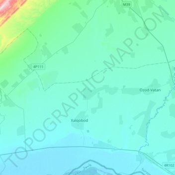
Name: Zang topographic map, elevation, terrain.
Location: Zang, Muzrabod Tumani, Surxondaryo Region, 190100, Uzbekistan (37.46639 66.77934 37.55636 67.12150)
Average elevation: 350 m
Minimum elevation: 279 m
Maximum elevation: 1,108 m
Other topographic maps
Click on a map to view its topography, its elevation and its terrain.
Рупат
Uzbekistan > Surxondaryo Region > Sariosiyo District > Сангардак
Рупат, Сангардак, Sariosiyo District, Surxondaryo Region, Uzbekistan
Average elevation: 1,576 m