
Lake Tahoe topographic map
Interactive map
Click on the map to display elevation.
About this map
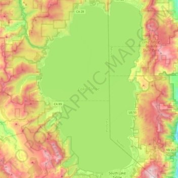
Name: Lake Tahoe topographic map, elevation, terrain.
Location: Lake Tahoe, Placer County, California, United States (38.92817 -120.16394 39.24901 -119.92606)
Average elevation: 2,077 m
Minimum elevation: 1,456 m
Maximum elevation: 2,965 m
Lake Tahoe has a dry-summer continental climate (Dsb in the Köppen climate classification), featuring warm, dry summers and chilly winters with regular snowfall. Mean annual precipitation ranges from over 55 inches (1,400 mm) for watersheds on the west side of the basin to about 26 inches (660 mm) near the lake on the east side of the basin. Most of the precipitation falls as snow between November and April, although rainstorms combined with rapid snowmelt account for the largest floods. There is a pronounced annual runoff of snowmelt in late spring and early summer, the timing of which varies from year to year. In some years, summertime monsoon storms from the Great Basin bring intense rainfall, especially to high elevations on the northeast side of the basin.
Other topographic maps
Click on a map to view its topography, its elevation and its terrain.
Placer County
United States > California > Placer County
Placer County, California, United States
Average elevation: 1,074 m
Carnelian Bay
United States > California > Placer County
Carnelian Bay, Placer County, California, 96140, United States
Average elevation: 1,977 m