
Make a donation
Mount Rushmore topographic map
Click on the map to display elevation.
Make a donation
Mount Rushmore
The Mount Rushmore National Memorial is a national memorial centered on a colossal sculpture carved into the granite face of Mount Rushmore (Lakota: Tȟuŋkášila Šákpe, or Six Grandfathers) in the Black Hills near Keystone, South Dakota, United States. Sculptor Gutzon Borglum designed the sculpture, called Shrine of Democracy, and oversaw the project's execution from 1927 to 1941 with the help of his son, Lincoln Borglum. The sculpture features the 60-foot-tall (18 m) heads of four United States presidents: George Washington (1732–1799), Thomas Jefferson (1743–1826), Theodore Roosevelt (1858–1919) and Abraham Lincoln (1809–1865). Mount Rushmore attracts more than two million visitors annually. The four presidents were chosen to represent the nation's birth, growth, development and preservation, respectively. The memorial park covers 1,278 acres (2.00 sq mi; 5.17 km2) and the mountain's elevation is 5,725 feet (1,745 m) above sea level.
Make a donation
About this map
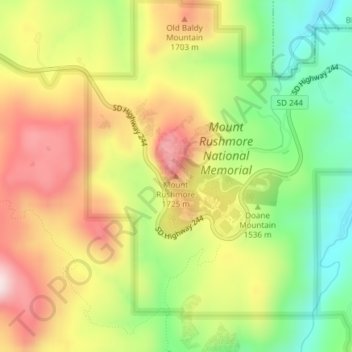
Name: Mount Rushmore topographic map, elevation, terrain.
Average elevation: 1,562 m
Minimum elevation: 1,367 m
Maximum elevation: 1,766 m
Make a donation
Other topographic maps
Click on a map to view its topography, its elevation and its terrain.