
Make a donation
Dolores County topographic map
Click on the map to display elevation.
Make a donation
Dolores County
Dolores County, like other counties in Colorado along its border with Utah, is split into two geographically distinct regions, and in fact, under normal travel conditions, it is necessary to leave the county to travel between the two regions. The western portion of the county (east of the Dolores River Canyon and along the Utah border) is the northern portion of the Great Sage Plain, relatively low (6500–7500 feet in elevation) and flat (but cut by large canyons, including that of the Dolores River itself), and consists of irrigated and dryland farming areas; it is especially well known for the cultivation of various varieties of beans, including pinto beans and many variety of old Anasazi beans. The central portion of the county has higher open grasslands with forested hills, ravines, and canyons, used for livestock raising. The eastern portion of the county is located in the highest peaks of the San Juan Mountains, around the old mining and modern tourist town of Rico, and except for cattle grazing in the San Juan National Forest, has virtually no agriculture, in part because its elevations range from 9,000 to 14,000+. Rico is developing in many ways as a bedroom community for the much wealthier town of Telluride in San Miguel County to the north.
Make a donation
About this map
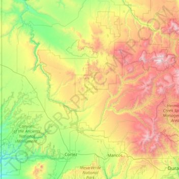
Name: Dolores County topographic map, elevation, terrain.
Location: Dolores County, Colorado, United States (37.48072 -109.04348 37.89640 -107.86155)
Average elevation: 2,385 m
Minimum elevation: 1,473 m
Maximum elevation: 4,265 m
Make a donation
Other topographic maps
Click on a map to view its topography, its elevation and its terrain.
Monument
United States > Colorado > El Paso County
Monument experiences a hemiboreal continental climate (Köppen Dfb) with warm, relatively rainy summers and cold, snowy winters. The semi-arid climate keeps the dew point very low in Monument year-round which causes the air to feel quite dry. Monument is part of the Front Range urban corridor and lies on the…
Average elevation: 2,160 m
Mountain Village
United States > Colorado > San Miguel County
Mountain Village is a home rule municipality in San Miguel County, southwestern Colorado. It is located just southwest of Telluride, Colorado in the San Juan Mountains. The elevation of the town rises above Telluride to 9,600 feet. The population was 1,264 at the 2020 census.
Average elevation: 2,917 m
Make a donation
Make a donation
Telluride
United States > Colorado > San Miguel County > Telluride
Telluride has an elevation of 8,750 feet (2,670 m) in an isolated spot in Southwest Colorado. From the west, Colorado Route 145 is the most common way into Telluride; two other passes enter the town, Imogene Pass and Black Bear Pass.
Average elevation: 3,246 m
Vail
United States > Colorado > Eagle County > Vail
Vail's average elevation is 8,150 feet (2484 m) above sea level. The town has a total area of 4.5 square miles (12 km2), with no lakes (there is, however, at least one pond). Gore Creek flows from east to west through the center of town.
Average elevation: 2,953 m
Colorado Springs
United States > Colorado > El Paso County > Colorado Springs
Snowfall is usually moderate and remains on the ground briefly because of direct sun, with the city receiving 38 inches (97 cm) per season, although the mountains to the west often receive in excess of triple that amount; March is the snowiest month in the region, both by total accumulation and number of days…
Average elevation: 2,229 m
Make a donation