
Homyel topographic map
Interactive map
Click on the map to display elevation.
Homyel
The terrain on which the city as a whole is built, is flat. On the right bank of the river, it is a gradually decreasing plain water-glacial and fluvial terrace of the Sozh river. The left bank is a low-lying alluvial plain. The highest elevation of 144 meters above sea level is found at the northern outskirts of Gomel, the lowest elevation of 115 m at the water boundary Sozh river. Novobelitskiy district, which is located on the left bank of the river (i.e., towards the south), has elevations averaging of 10–15 meters lower than the northern and central parts of the city.
About this map
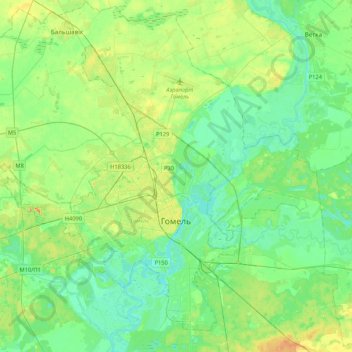
Name: Homyel topographic map, elevation, terrain.
Location: Homyel, Homyel Region, Belarus (52.34327 30.74695 52.57076 31.17153)
Average elevation: 130 m
Minimum elevation: 109 m
Maximum elevation: 186 m