
Figeac topographic map
Interactive map
Click on the map to display elevation.
About this map
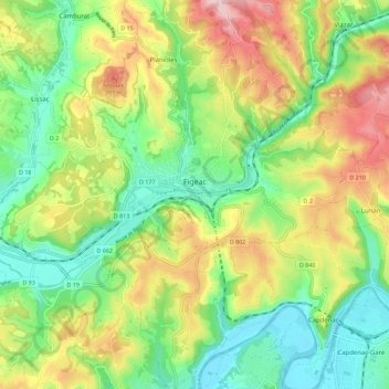
Name: Figeac topographic map, elevation, terrain.
Location: Figeac, Lot, Occitania, Metropolitan France, 46100, France (44.56716 1.96733 44.64586 2.07972)
Average elevation: 276 m
Minimum elevation: 159 m
Maximum elevation: 459 m
Other topographic maps
Click on a map to view its topography, its elevation and its terrain.
Rocamadour
France > Occitania > Lot > Rocamadour
Rocamadour, Gourdon, Lot, Occitania, Metropolitan France, 46500, France
Average elevation: 247 m