
Mucuchíes topographic map
Interactive map
Click on the map to display elevation.
About this map
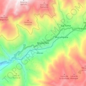
Name: Mucuchíes topographic map, elevation, terrain.
Location: Mucuchíes, Parroquia Rangel, Municipio Rangel, Venezuela (8.70901 -70.96006 8.78901 -70.88006)
Average elevation: 3,403 m
Minimum elevation: 2,548 m
Maximum elevation: 4,348 m
Mucuchíes is a town in the Rangel Municipality of Mérida State, Venezuela. It is at an altitude of 2,983 meters and has a cool climate, with an average temperature of 11 °C. The town was founded by Bartolomé Gil Naranjo in 1586.
Other topographic maps
Click on a map to view its topography, its elevation and its terrain.
Aguas termales La Musui
Venezuela > Municipio Rangel > Mucurubá > La Cruz
Aguas termales La Musui, Carretera Trasandina Mérida - Muchuchíes, La Cruz, Mucurubá, Parroquia Rangel, Municipio Rangel, Venezuela
Average elevation: 3,366 m