
Thank you for supporting this site ❤️
Make a donation
Make a donation
Bantul Regency topographic map
Click on the map to display elevation.
Thank you for supporting this site ❤️
Make a donation
Make a donation
About this map
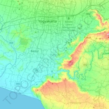
Name: Bantul Regency topographic map, elevation, terrain.
Average elevation: 128 m
Minimum elevation: 0 m
Maximum elevation: 608 m
Thank you for supporting this site ❤️
Make a donation
Make a donation
Other topographic maps
Click on a map to view its topography, its elevation and its terrain.
Embung Tambakboyo
Indonesia > Special Region of Yogyakarta > Sleman Regency > Condongcatur
Average elevation: 164 m
Purba
Indonesia > Special Region of Yogyakarta > Gunung Kidul Regency > Nglanggeran
Average elevation: 465 m