
Thank you for supporting this site ❤️
Make a donation
Make a donation
Montpezat topographic map
Click on the map to display elevation.
Thank you for supporting this site ❤️
Make a donation
Make a donation
About this map
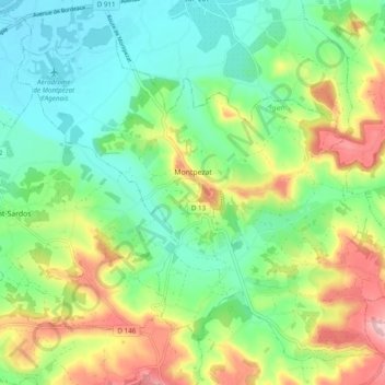
Name: Montpezat topographic map, elevation, terrain.
Average elevation: 104 m
Minimum elevation: 37 m
Maximum elevation: 225 m
Thank you for supporting this site ❤️
Make a donation
Make a donation
Other topographic maps
Click on a map to view its topography, its elevation and its terrain.
Château de Dolmayrac
France > Nouvelle-Aquitaine > Lot-et-Garonne > Dolmayrac
Average elevation: 128 m
Thank you for supporting this site ❤️
Make a donation
Make a donation
Bissières
France > Nouvelle-Aquitaine > Lot-et-Garonne > Sainte-Colombe-de-Villeneuve
Average elevation: 161 m