
Einsiedeln topographic map
Interactive map
Click on the map to display elevation.
Einsiedeln
Einsiedeln is located approximately 7.5 km (4.7 mi) from the southern end of the Lake of Zurich, and 2 km (1.2 mi) west of the artificial Sihlsee lake. It is on a plateau (ca. 880 m (2,890 ft) above sea level). The town is located at an altitude of 470 m (1,540 ft) higher than Zurich, with which it has a railway connection.
About this map
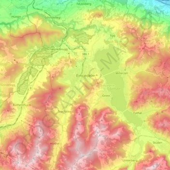
Name: Einsiedeln topographic map, elevation, terrain.
Location: Einsiedeln, Schwyz, 8840, Switzerland (47.06327 8.68420 47.17828 8.88661)
Average elevation: 1,023 m
Minimum elevation: 412 m
Maximum elevation: 1,590 m