
Thank you for supporting this site ❤️
Make a donation
Make a donation
Show Low topographic map
Click on the map to display elevation.
Thank you for supporting this site ❤️
Make a donation
Make a donation
Show Low
Show Low is a city in Navajo County, Arizona. It lies on the Mogollon Rim in east central Arizona, at an elevation of 6,345 feet (1,934 m). The city was established in 1870 and incorporated in 1953. According to the 2010 census, the population of the city was 10,660.
Thank you for supporting this site ❤️
Make a donation
Make a donation
About this map
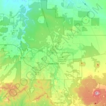
Name: Show Low topographic map, elevation, terrain.
Location: Show Low, Navajo County, Arizona, 85901, United States (34.18376 -110.10385 34.35921 -109.94456)
Average elevation: 1,957 m
Minimum elevation: 1,794 m
Maximum elevation: 2,309 m
Thank you for supporting this site ❤️
Make a donation
Make a donation