
Thank you for supporting this site ❤️
Make a donation
Make a donation
Sohra (Cherrapunji) topographic map
Click on the map to display elevation.
Thank you for supporting this site ❤️
Make a donation
Make a donation
Sohra (Cherrapunji)
It has an average elevation of 1,430 metres (4,690 ft) and sits on a plateau in the southern part of the Khasi Hills, facing the plains of Bangladesh. The plateau rises 660 meters above the surrounding valleys.
Thank you for supporting this site ❤️
Make a donation
Make a donation
About this map
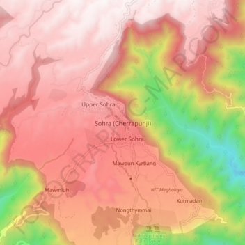
Name: Sohra (Cherrapunji) topographic map, elevation, terrain.
Average elevation: 1,169 m
Minimum elevation: 261 m
Maximum elevation: 1,652 m
Thank you for supporting this site ❤️
Make a donation
Make a donation
Other topographic maps
Click on a map to view its topography, its elevation and its terrain.