
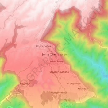
Sohra (Cherrapunji) topographic map
Interactive map
Click on the map to display elevation.
About this map
Name: Sohra (Cherrapunji) topographic map, elevation, terrain.
Average elevation: 1,169 m
Minimum elevation: 261 m
Maximum elevation: 1,652 m
It has an average elevation of 1,430 metres (4,690 ft) and sits on a plateau in the southern part of the Khasi Hills, facing the plains of Bangladesh. The plateau rises 660 meters above the surrounding valleys.
Other topographic maps
Click on a map to view its topography, its elevation and its terrain.
Sohsarat
India > Meghalaya > Shella Bholaganj > Nongwar
Sohsarat, Nongwar, Shella Bholaganj, East Khasi Hills District, Meghalaya, India
Average elevation: 372 m
Nongthymmai
India > Meghalaya > Shella Bholaganj
Nongthymmai, Shella Bholaganj, East Khasi Hills District, Meghalaya, 793108, India
Average elevation: 1,123 m
Suktia
India > Meghalaya > Shella Bholaganj
Suktia, Shella Bholaganj, East Khasi Hills, Meghalaya, India
Average elevation: 486 m
Nohsngithiang Falls (Seven Sisters)
India > Meghalaya > Shella Bholaganj
Nohsngithiang Falls (Seven Sisters), Shella Bholaganj, East Khasi Hills, Meghalaya, 793108, India
Average elevation: 1,043 m
Nohkalikai Falls View Point
India > Meghalaya > Shella Bholaganj
Nohkalikai Falls View Point, Root bridge, Shella Bholaganj, East Khasi Hills, Meghalaya, 793108, India
Average elevation: 1,156 m