
Thank you for supporting this site ❤️
Make a donation
Make a donation
Guildford topographic map
Click on the map to display elevation.
Thank you for supporting this site ❤️
Make a donation
Make a donation
About this map
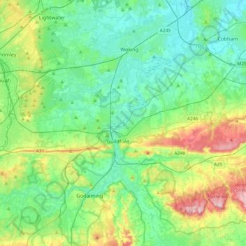
Name: Guildford topographic map, elevation, terrain.
Location: Guildford, Surrey, England, United Kingdom (51.17319 -0.74834 51.33152 -0.38717)
Average elevation: 74 m
Minimum elevation: 12 m
Maximum elevation: 256 m
Thank you for supporting this site ❤️
Make a donation
Make a donation
Other topographic maps
Click on a map to view its topography, its elevation and its terrain.