
Annecy topographic map
Interactive map
Click on the map to display elevation.
About this map
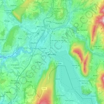
Name: Annecy topographic map, elevation, terrain.
Average elevation: 610 m
Minimum elevation: 362 m
Maximum elevation: 1,551 m
Annecy has an oceanic climate (Köppen: Cfb) despite its relatively far inland position. Influenced by its elevation, summers are rather moderate on average, although they can be highly variable with extreme heat spikes. Winters see occasional freezing temperatures, but temperatures most often stay in the single-digits during the daytime with frequent cold rain. Air frosts are normal during the night and snowfall is not uncommon.
Other topographic maps
Click on a map to view its topography, its elevation and its terrain.
Entremont
France > Auvergne-Rhône-Alpes > Upper Savoy > Glières-Val-de-Borne
Entremont, Glières-Val-de-Borne, Bonneville, Upper Savoy, Auvergne-Rhône-Alpes, Metropolitan France, 74130, France
Average elevation: 1,302 m
Massongy
France > Auvergne-Rhône-Alpes > Upper Savoy
Massongy, Thonon-les-Bains, Upper Savoy, Auvergne-Rhône-Alpes, Metropolitan France, 74140, France
Average elevation: 454 m