
Thank you for supporting this site ❤️
Make a donation
Make a donation
Liberty topographic map
Click on the map to display elevation.
Thank you for supporting this site ❤️
Make a donation
Make a donation
About this map
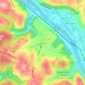
Name: Liberty topographic map, elevation, terrain.
Location: Liberty, Allegheny County, Pennsylvania, United States (40.31471 -79.87597 40.33667 -79.84078)
Average elevation: 283 m
Minimum elevation: 220 m
Maximum elevation: 358 m
Thank you for supporting this site ❤️
Make a donation
Make a donation
Other topographic maps
Click on a map to view its topography, its elevation and its terrain.
Culmerville
United States > Pennsylvania > Allegheny County > West Deer Township
Average elevation: 341 m
Coverdale
United States > Pennsylvania > Allegheny County > Bethel Park > Coverdale
Average elevation: 354 m