
Ixelles - Elsene topographic map
Interactive map
Click on the map to display elevation.
About this map
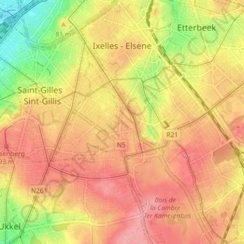
Name: Ixelles - Elsene topographic map, elevation, terrain.
Location: Ixelles - Elsene, Brussels-Capital, Belgium (50.80069 4.34793 50.84063 4.40340)
Average elevation: 82 m
Minimum elevation: 20 m
Maximum elevation: 119 m
Other topographic maps
Click on a map to view its topography, its elevation and its terrain.
Ganshoren
Belgium > Brussels-Capital > Ganshoren
Ganshoren, Brussels-Capital, 1083, Belgium
Average elevation: 46 m