
Thank you for supporting this site ❤️
Make a donation
Make a donation
Thiruvanchoor topographic map
Click on the map to display elevation.
Thank you for supporting this site ❤️
Make a donation
Make a donation
About this map
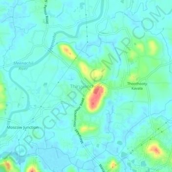
Name: Thiruvanchoor topographic map, elevation, terrain.
Location: Thiruvanchoor, Kottayam, Kerala, 686032, India (9.60257 76.55506 9.64257 76.59506)
Average elevation: 11 m
Minimum elevation: -1 m
Maximum elevation: 60 m
Thank you for supporting this site ❤️
Make a donation
Make a donation
Other topographic maps
Click on a map to view its topography, its elevation and its terrain.