
Make a donation
Khammouane topographic map
Click on the map to display elevation.
Make a donation
Khammouane
The 68,125 hectare Hin Nam No (also Hin Namno) Important Bird Area (IBA) is in the Hin Namno NBCA. Its topography features limestone karst outcrops, undulating limestone hills, as well as valleys. The IBA's habitat is characterized by sparsely vegetated limestone karst, semi-evergreen tropical rain forest, mixed deciduous forest, moist deciduous tropical forest, and wet evergreen forest. Vietnamese crested argus (Rheinardia ocellata) and Austen's brown hornbill (Anorrhinus austeni) are classified as near threatened. The inornate squirrel (Callosciurus inornatus) has been identified as important fauna within the IBA.
Make a donation
About this map
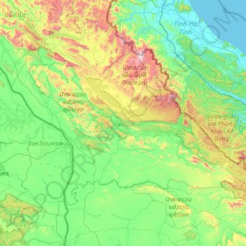
Name: Khammouane topographic map, elevation, terrain.
Location: Khammouane, Laos (16.90165 104.27040 18.26656 106.42598)
Average elevation: 339 m
Minimum elevation: -1 m
Maximum elevation: 2,212 m
Make a donation
Other topographic maps
Click on a map to view its topography, its elevation and its terrain.
Sengsavang
Laos > Vientiane Prefecture > Xaysetha District > Vientiane Capital
Average elevation: 171 m
Make a donation
B. Phonthongchommani
Laos > Vientiane Prefecture > Chanthabuly District > Vientiane Capital
Average elevation: 173 m
Make a donation
B. Phonsavang
Laos > Vientiane Prefecture > Chanthabuly District > Vientiane Capital
Average elevation: 174 m
Phonpapao
Laos > Vientiane Prefecture > Sisattanak District > Vientiane Capital
Average elevation: 170 m
Make a donation
Hatsadi
Laos > Vientiane Prefecture > Chanthabuly District > Vientiane Capital
Average elevation: 170 m
Make a donation