Geolocate

Lac Blanc topographic map

Interactive map

Click on the map to display elevation.

About this map

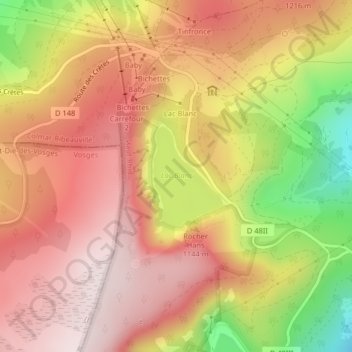
Name: Lac Blanc topographic map, elevation, terrain.

Location: Lac Blanc, Orbey, Colmar-Ribeauvillé, Haut-Rhin, Grand Est, France métropolitaine, 68370, France (48.12326 7.08787 48.13094 7.09589)

Average elevation: 1,111 m

Minimum elevation: 806 m

Maximum elevation: 1,297 m

Le lac Blanc est un lac d'altitude du massif des Vosges. Une importante roche appelée rocher Hans domine le lac, elle-même coiffée d'une statue de la Vierge.

Wikipedia (CC-BY-SA 3.0)

Other topographic maps

Click on a map to view its topography, its elevation and its terrain.

Les Basses Huttes

France > Grand Est > Haut-Rhin > Orbey

Les Basses Huttes, Orbey, Colmar-Ribeauvillé, Haut-Rhin, Grand Est, France métropolitaine, 68370, France

Average elevation: 809 m

Pairis

France > Grand Est > Haut-Rhin > Orbey

Pairis, Orbey, Colmar-Ribeauvillé, Haut-Rhin, Grand Est, France métropolitaine, 68370, France

Average elevation: 801 m

Tête des Faux

France > Grand Est > Haut-Rhin > Orbey

Tête des Faux, Orbey, Colmar-Ribeauvillé, Haut-Rhin, Grand Est, France métropolitaine, 68370, France

Average elevation: 994 m

Les Hautes-Huttes

France > Grand Est > Haut-Rhin > Orbey

Les Hautes-Huttes, Orbey, Colmar-Ribeauvillé, Haut-Rhin, Grand Est, France métropolitaine, 68370, France

Average elevation: 868 m

Remomont

France > Grand Est > Haut-Rhin > Orbey

Remomont, Orbey, Colmar-Ribeauvillé, Haut-Rhin, Grand Est, France métropolitaine, 68370, France

Average elevation: 696 m

Lac Noir

France > Grand Est > Haut-Rhin > Orbey

Lac Noir, Orbey, Colmar-Ribeauvillé, Haut-Rhin, Grand Est, France métropolitaine, 68370, France

Average elevation: 1,052 m

Auberge-Refuge Le Blancrupt

France > Grand Est > Haut-Rhin > Orbey

Auberge-Refuge Le Blancrupt, D 48II, Orbey, Colmar-Ribeauvillé, Haut-Rhin, Grand Est, France métropolitaine, 68370, France

Average elevation: 1,080 m