
White Pine County topographic map
Interactive map
Click on the map to display elevation.
About this map
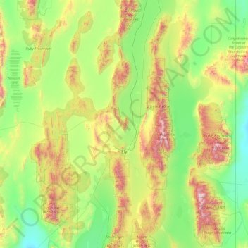
Name: White Pine County topographic map, elevation, terrain.
Location: White Pine County, Nevada, United States (38.67735 -115.90822 40.12856 -114.04656)
Average elevation: 2,049 m
Minimum elevation: 1,468 m
Maximum elevation: 3,839 m
In the southeastern part of the county within Great Basin National Park lies 13,065 ft (3982 m) Wheeler Peak, the tallest independent mountain within Nevada and the second-highest point within the state (the highest point being Boundary Peak). It is also the most topographically prominent peak in the county and the second-most prominent peak in Nevada (after Mount Charleston).
Other topographic maps
Click on a map to view its topography, its elevation and its terrain.
Aurora Hill
United States > Nevada > Mineral County
Aurora Hill, Mineral County, Nevada, United States
Average elevation: 2,272 m
Riverside
United States > Nevada > Clark County > Mesquite
Riverside, Mesquite, Clark County, Nevada, United States
Average elevation: 483 m
Paradise
United States > Nevada > Clark County
Paradise, Clark County, Nevada, United States
Average elevation: 685 m
Reno
United States > Nevada > Washoe County
Reno, Washoe County, Nevada, United States
Average elevation: 1,650 m
Las Vegas
United States > Nevada > Clark County
Las Vegas, Clark County, Nevada, United States
Average elevation: 756 m
Pershing County
Pershing County, Nevada, United States
Average elevation: 1,449 m
North Las Vegas
United States > Nevada > Clark County
North Las Vegas, Clark County, Nevada, United States
Average elevation: 684 m