Geolocate

Muhafazat Dayr az Zawr topographic map

Interactive map

Click on the map to display elevation.

About this map

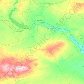
Name: Muhafazat Dayr az Zawr topographic map, elevation, terrain.

Location: Muhafazat Dayr az Zawr, Al-Mansurah Subdistrict, Al-Thawrah District, Ar-Raqqah Governorate, Syria (34.50000 38.00000 36.50000 40.00000)

Average elevation: 421 m

Minimum elevation: 196 m

Maximum elevation: 1,375 m

Other topographic maps

Click on a map to view its topography, its elevation and its terrain.

Hawra

Syria > Ar-Raqqah Governorate

Hawra, Al-Mansurah Subdistrict, Al-Thawrah District, Ar-Raqqah Governorate, Syria

Average elevation: 296 m

Raqqa

Syria > Ar-Raqqah Governorate

Raqqa, Raqqah Subdistrict, Raqqa District, Ar-Raqqah Governorate, Syria

Average elevation: 287 m