
Thank you for supporting this site ❤️
Make a donation
Make a donation
La Trinité topographic map
Click on the map to display elevation.
Thank you for supporting this site ❤️
Make a donation
Make a donation
About this map
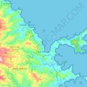
Name: La Trinité topographic map, elevation, terrain.
Location: La Trinité, Martinique, 97220, France (14.69591 -61.02188 14.80721 -60.87125)
Average elevation: 69 m
Minimum elevation: -1 m
Maximum elevation: 456 m
Thank you for supporting this site ❤️
Make a donation
Make a donation
Other topographic maps
Click on a map to view its topography, its elevation and its terrain.