
Thank you for supporting this site ❤️
Make a donation
Make a donation
Finistère topographic map
Click on the map to display elevation.
Thank you for supporting this site ❤️
Make a donation
Make a donation
About this map
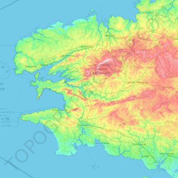
Name: Finistère topographic map, elevation, terrain.
Location: Finistère, Brittany, Metropolitan France, France (47.70128 -5.14403 48.75719 -3.38665)
Average elevation: 69 m
Minimum elevation: -1 m
Maximum elevation: 376 m
Thank you for supporting this site ❤️
Make a donation
Make a donation
Other topographic maps
Click on a map to view its topography, its elevation and its terrain.