
Make a donation
Kiska Island topographic map
Click on the map to display elevation.
Make a donation
Kiska Island
Renamed "Skira", the island was used as the setting for the Codemasters video game Operation Flashpoint: Dragon Rising. The fictionalized version of the island is relocated closer to Russia and China, but the island's topography is replicated near-exactly, with elements of the game designed around it, instead of vice versa.
Make a donation
About this map
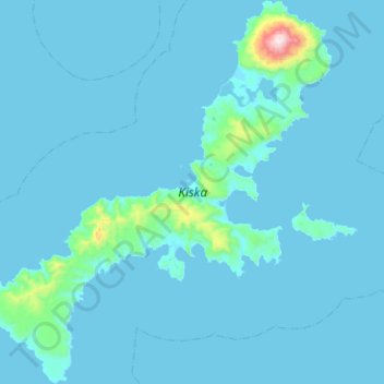
Name: Kiska Island topographic map, elevation, terrain.
Location: Kiska Island, Unorganized Borough, Alaska, United States (51.82561 177.19781 52.13572 177.67330)
Average elevation: 40 m
Minimum elevation: -2 m
Maximum elevation: 1,184 m
Make a donation
Other topographic maps
Click on a map to view its topography, its elevation and its terrain.
Lituya Glacier
United States > Alaska > Unorganized Borough
It is partially responsible for creating the 1958 Lituya Bay megatsunami. The glacier, which has receded over the years, carved Lituya Bay into a unique topographic phenomenon with steep walls, a very deep submerged bottom, and a very narrow entrance to the ocean which created the opportunity for a megatsunami…
Average elevation: 952 m