
Thank you for supporting this site ❤️
Make a donation
Make a donation
Kumarakom topographic map
Click on the map to display elevation.
Thank you for supporting this site ❤️
Make a donation
Make a donation
About this map
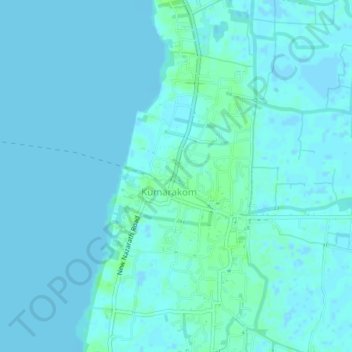
Name: Kumarakom topographic map, elevation, terrain.
Location: Kumarakom, Kottayam, Kerala, 686563, India (9.57605 76.41054 9.61605 76.45054)
Average elevation: 2 m
Minimum elevation: -4 m
Maximum elevation: 7 m
Thank you for supporting this site ❤️
Make a donation
Make a donation
Other topographic maps
Click on a map to view its topography, its elevation and its terrain.
Thank you for supporting this site ❤️
Make a donation
Make a donation
Thank you for supporting this site ❤️
Make a donation
Make a donation