
Make a donation
Champasak Province topographic map
Click on the map to display elevation.
Make a donation
Champasak Province
The Mekong Channel from Phou Xiang Thong to Siphandon Important Bird Area (IBA) is 34,200 ha (85,000 acres) in size. A portion of the IBA (10,000 hectares) overlaps with the 120,000 ha (300,000 acres) Phou Xieng Thong National Protected Area. The IBA encompasses two provinces, Champasak and Salavan. The IBA is at an elevation of 40–50 m (130–160 ft). Its topography consists of earth banks, rocky banks, rocky islands, sandbars, low vegetated islands, rocky islets, and sandy beaches. Notable avifauna include Laos's last known nesting little terns, river lapwings, river terns, small pratincoles and wire-tailed swallows.
Make a donation
About this map
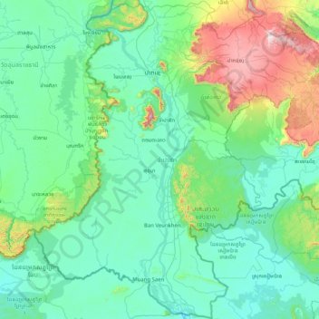
Name: Champasak Province topographic map, elevation, terrain.
Location: Champasak Province, Laos (13.90968 105.20523 15.47013 106.82819)
Average elevation: 262 m
Minimum elevation: 48 m
Maximum elevation: 1,654 m
Make a donation
Other topographic maps
Click on a map to view its topography, its elevation and its terrain.
Sengsavang
Laos > Vientiane Prefecture > Xaysetha District > Vientiane Capital
Average elevation: 171 m
Make a donation
B. Phonthongchommani
Laos > Vientiane Prefecture > Chanthabuly District > Vientiane Capital
Average elevation: 173 m
Make a donation
B. Phonsavang
Laos > Vientiane Prefecture > Chanthabuly District > Vientiane Capital
Average elevation: 174 m
Phonpapao
Laos > Vientiane Prefecture > Sisattanak District > Vientiane Capital
Average elevation: 170 m
Make a donation
Hatsadi
Laos > Vientiane Prefecture > Chanthabuly District > Vientiane Capital
Average elevation: 170 m
Make a donation