Geolocate

Manarcadu topographic map

Interactive map

Click on the map to display elevation.

About this map

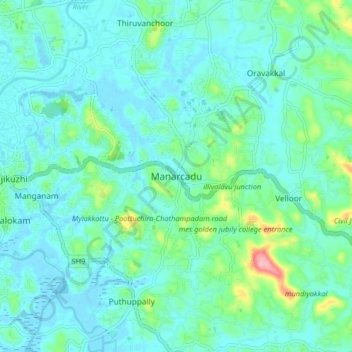
Name: Manarcadu topographic map, elevation, terrain.

Location: Manarcadu, Kottayam, Kerala, 686019, India (9.54778 76.54227 9.62778 76.62227)

Average elevation: 23 m

Minimum elevation: -2 m

Maximum elevation: 129 m

Other topographic maps

Click on a map to view its topography, its elevation and its terrain.

Manganam

India > Kerala > Kottayam

Manganam, Kottayam, Kottayam District, Kerala, 686018, India

Average elevation: 16 m

Pampady

India > Kerala > Kottayam

Pampady, Kottayam, Kottayam District, Kerala, 686502, India

Average elevation: 55 m

Velloor

India > Kerala > Kottayam

Velloor, Kottayam, Kottayam District, Kerala, 686501, India

Average elevation: 38 m

Meenadom

India > Kerala > Kottayam > Pariyaram

Meenadom, Pariyaram, Kottayam, Kottayam District, Kerala, 686021, India

Average elevation: 36 m

Sankranthi

India > Kerala > Kottayam > Kottayam

Sankranthi, Kumaranalloor, Kottayam, Kerala, 686028, India

Average elevation: 15 m

Kottayam

India > Kerala > Kottayam

Kottayam, Kottayam District, Kerala, 686001, India

Average elevation: 19 m

Kumarakom

India > Kerala > Kottayam

Kumarakom, Kottayam, Kerala, 686563, India

Average elevation: 2 m

Ettumanoor

India > Kerala > Kottayam

Ettumanoor, Kottayam, Kerala, 686631, India

Average elevation: 22 m

Thiruvanchoor

India > Kerala > Kottayam > Thiruvanchoor

Thiruvanchoor, Kottayam, Kerala, 686032, India

Average elevation: 11 m

Alapuzha

India > Kerala > Kottayam > Kottayam

Alapuzha, Devalokam, Kottayam, Kerala, India

Average elevation: 10 m

Illickal Thazhe

India > Kerala > Kottayam > Kozhikombu > Illickal Thazhe

Illickal Thazhe, Kozhikombu, Kottayam, Kerala, 686635, India

Average elevation: 46 m

Karapuzha

India > Kerala > Kottayam > Kottayam

Karapuzha, Kottayam, Kerala, India

Average elevation: 7 m