
San Fernando topographic map
Interactive map
Click on the map to display elevation.
About this map
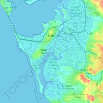
Name: San Fernando topographic map, elevation, terrain.
Location: San Fernando, Bay of Cádiz, Cádiz, Andalusia, Spain (36.37861 -6.24230 36.50996 -6.16823)
Average elevation: 6 m
Minimum elevation: -3 m
Maximum elevation: 52 m
Other topographic maps
Click on a map to view its topography, its elevation and its terrain.
Puerto Real
Spain > Andalusia > Bay of Cádiz > Puerto Real
Puerto Real, Bay of Cádiz, Cádiz, Andalusia, Spain
Average elevation: 18 m