
Thank you for supporting this site ❤️
Make a donation
Make a donation
Draguignan topographic map
Click on the map to display elevation.
Thank you for supporting this site ❤️
Make a donation
Make a donation
Draguignan
The elevation is 200 m. The highest hill near Draguignan is Malmont (551 m). The main river near Draguignan is the Nartuby.
Thank you for supporting this site ❤️
Make a donation
Make a donation
About this map
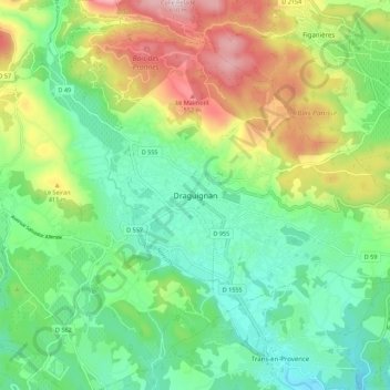
Name: Draguignan topographic map, elevation, terrain.
Average elevation: 288 m
Minimum elevation: 109 m
Maximum elevation: 637 m
Thank you for supporting this site ❤️
Make a donation
Make a donation
Other topographic maps
Click on a map to view its topography, its elevation and its terrain.
Jospeh Allet
France > Provence-Alpes-Côte d'Azur > Var > Draguignan > Draguignan > Saint François
Average elevation: 207 m