
Thank you for supporting this site ❤️
Make a donation
Make a donation
Rishikesh topographic map
Click on the map to display elevation.
Thank you for supporting this site ❤️
Make a donation
Make a donation
Rishikesh
Rishikesh is at 30°06′12″N 78°17′41″E / 30.103368°N 78.294754°E / 30.103368; 78.294754. It has an average elevation of 372 metres (1,220 ft). The town is located in the Tehri Garhwal region of the northern Indian state of Uttarakhand.
Thank you for supporting this site ❤️
Make a donation
Make a donation
About this map
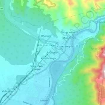
Name: Rishikesh topographic map, elevation, terrain.
Location: Rishikesh, Dehradun, Uttarakhand, 249201, India (30.06865 78.25162 30.14865 78.33162)
Average elevation: 497 m
Minimum elevation: 323 m
Maximum elevation: 1,363 m
Thank you for supporting this site ❤️
Make a donation
Make a donation