
Thank you for supporting this site ❤️
Make a donation
Make a donation
Harapanahalli topographic map
Click on the map to display elevation.
Thank you for supporting this site ❤️
Make a donation
Make a donation
Harapanahalli
It has an average elevation of 633 metres (2,077 ft) above the Mean sea level. Harapanahalli is surrounded by several districts like Davanagere in the South, Chithradurga in the Southeast, Haveri in the West.
Thank you for supporting this site ❤️
Make a donation
Make a donation
About this map
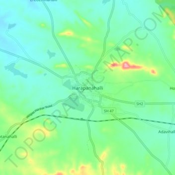
Name: Harapanahalli topographic map, elevation, terrain.
Average elevation: 626 m
Minimum elevation: 584 m
Maximum elevation: 757 m
Thank you for supporting this site ❤️
Make a donation
Make a donation