
Thank you for supporting this site ❤️
Make a donation
Make a donation
Challhuahuacho topographic map
Click on the map to display elevation.
Thank you for supporting this site ❤️
Make a donation
Make a donation
About this map
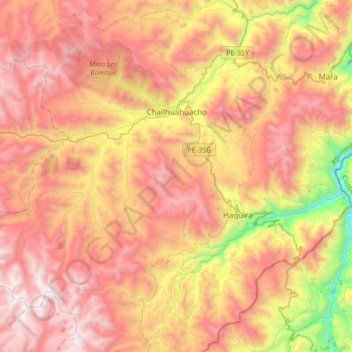
Name: Challhuahuacho topographic map, elevation, terrain.
Location: Challhuahuacho, Province of Cotabambas, Apurímac, Peru (-14.30396 -72.47976 -14.05243 -72.14408)
Average elevation: 4,040 m
Minimum elevation: 2,934 m
Maximum elevation: 4,889 m
Thank you for supporting this site ❤️
Make a donation
Make a donation
Other topographic maps
Click on a map to view its topography, its elevation and its terrain.
Abancay
Abancay is located at an elevation of 2,377 metres (7,799 ft) above sea level in the southern Peruvian Andes, above the Pachachaca River, and straddles the Marino River. Because of its dry mountain and famous year-round warm weather it is known as "The Eternal Springtime Valley". The nearest cities are Cusco,…
Average elevation: 3,400 m
Thank you for supporting this site ❤️
Make a donation
Make a donation
Thank you for supporting this site ❤️
Make a donation
Make a donation
Thank you for supporting this site ❤️
Make a donation
Make a donation
Thank you for supporting this site ❤️
Make a donation
Make a donation
Thank you for supporting this site ❤️
Make a donation
Make a donation