
Capones Island topographic map
Interactive map
Click on the map to display elevation.
About this map
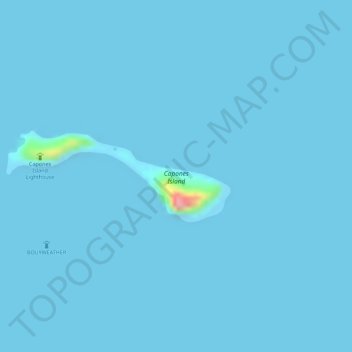
Name: Capones Island topographic map, elevation, terrain.
Location: Capones Island, Zambales, Central Luzon, Philippines (14.91056 120.00634 14.91757 120.02413)
Average elevation: 1 m
Minimum elevation: -1 m
Maximum elevation: 111 m
Other topographic maps
Click on a map to view its topography, its elevation and its terrain.
Mapanuepe Lake
Philippines > Zambales > Aglao
Mapanuepe Lake, Aglao, Zambales, Central Luzon, Philippines
Average elevation: 188 m
Botolan
Botolan, Zambales, Central Luzon, 2202, Philippines
Average elevation: 22 m